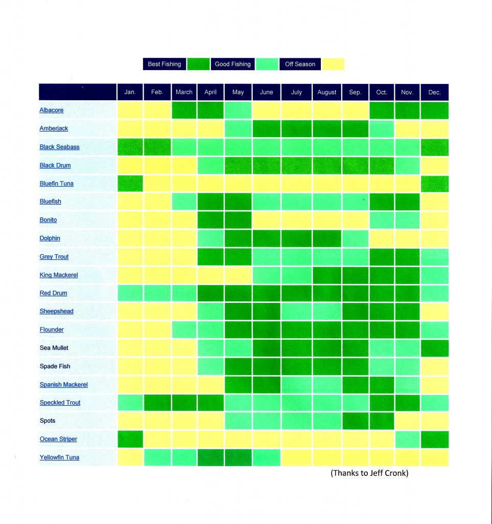
Posted by & filed under Articles.

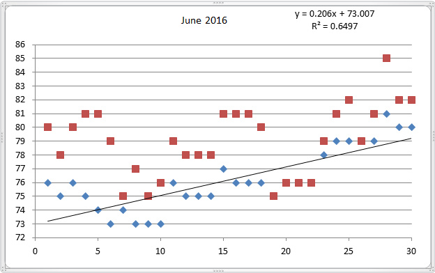
Emerald Isle Water Temperatures for June 2016

Surf at Bogue Pier ranged from Low of 73-degrees to a high of 81-degrees with an average of 76.2-degrees (blue diamonds). Bogue Sound had a low of 75-degrees and a high of 85-degrees with an average of 79.1-degrees (red squares). The rate of increase (slope of the line) was about 0.21 degrees/day. Last year, as you remember the sharks, we hit 80 before the end of May and the average surf was 80.9 for June 2015, the sound 83.1. In 2016 we got into the 80, the last few days of June. June was very normal for 2016.

Fullscreen capture 712016 15043 PM.bmp

Posted by & filed under Articles, Fishing.

Emerald Isle Water Temperatures for May 2016

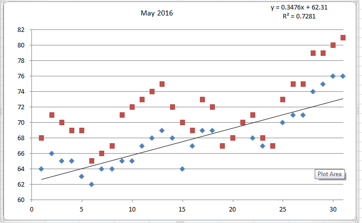
Surf at Bogue Pier ranged from Low of 62-degrees to a high of 76-degrees with an average of 67.9-degrees (blue diamonds). Bogue Sound had a low of 65-degrees and a high of 81-degrees with an average of 71.6-degrees (red squares). The rate of increase (slope of the line) was about 0.35 degrees/day for theFullscreen capture 5312016 11421 PM.bmp surf.

Posted by & filed under Articles, Fishing.

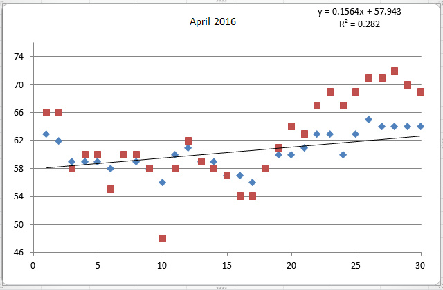
Surf at Bogue Pier ranged from Low of 56-degrees to a high of 64-degrees with an average of 60.4-degrees (blue diamonds). Bogue Sound had a low of 48-degrees and a high of 72-degrees with an average of 62.1-degrees (red squares). Fullscreen capture 5312016 11926 PM.bmp

Posted by & filed under Articles.

Of water temperatures and shark bites, 2015.

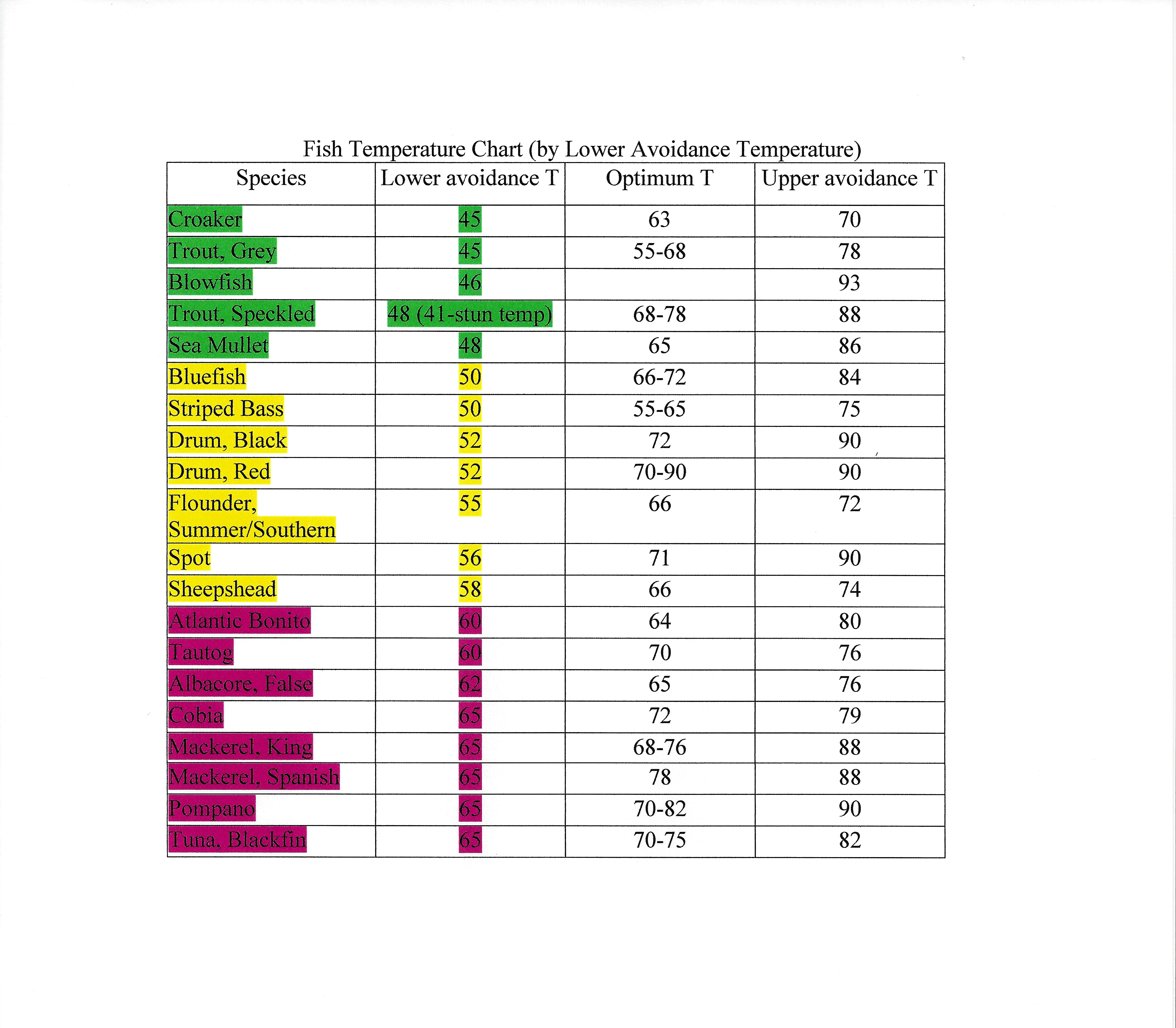
Remember the Goldilocks syndrome, not too cold, not too hot…just right! I am a retired PhD chemist, locally known as Dr. Bogus and have and have taken water temperatures in Bogue Sound and in the ocean from Bogue Pier for over two-decades most of that time on a daily basis. Why? Water temperatures greatly influences the “who and when” of our migrating fish stocks, both their comings and goings with the seasons. Fish, like porridge to Goldilocks, have a lower and upper temperature comfort range and a temperature that is “juuuuust” right.

Watching the water temperatures we can anticipate the arrivals and departures of our seasonal piscatorial friends and even anticipate events such as cold stun or cold kill of sensitive fish such as speckled trout that we have seen in recent years, and sea turtle strandings too.

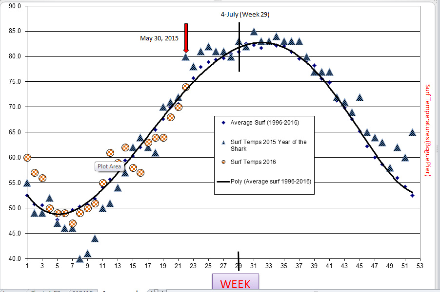
According to my local Emerald Isle water temperature year data 2015 was a strikingly unusual. This was the first time I have recorded ocean water temperatures in each of the months of January, February and March of under 50-degrees Fahrenheit. It was truly an unusually cold and persistently cold winter. Fishing was sluggish and turtle strandings were increased. Then during the last two weeks of May of 2015, our ocean water temperatures suddenly shot up dramatically from 70 to 80-degrees by May 30, 2015, a temperature so strikingly unusual for the end of May, as 80-degree surf is usually reserved for July 4th, and our Independence Day celebrations. First too cold, then too hot, what a year we had in 2015. This trend was the norm for the Atlantic coast in general and not only our portion that we lovingly call The Crystal Coast.

We already know the tragic results of the early warm water temperatures, the premature arrival of both north going sharks and south going bathers leading unfortunately to above normal shark-human interactions. And in response for the public safety and public concern, several local communities imposed beach fishing restrictions, with dubious efficacy.

As you can see I agree with the analysis of many scientific experts as to the reason for last year’s upsurge of shark attacks, which of course are rare, but I also wanted to add some quantitative data on local water temperatures and their effects on migratory fish species in support of their conclusions. If you are interested, check out my web site www.ncoif.com where I post much of my water temperature data for your use and information. This is hoping we all have a safe and fun 2016 beach season.

Fullscreen capture 5312016 125640 PM.bmp

Above is a plot (by week) of surf water temperatures at Bogue Pier for 2015 (blue triangles) and 2016 (checkered circles, through May 2016)

Posted by & filed under Fishing, Fishing News.

Release: Immediate Contact: Patricia Smith
Date: May 20, 2016 Phone: 252-726-7021 or 252-342-0642
 

Recreational cobia regulations go into effect Monday


MOREHEAD CITY –The N.C. Division of Marine Fisheries has issued a proclamation consistent with the North Carolina Marine Fisheries Commission’s decision to impose restrictions on the recreational cobia fishery. On Thursday the commission voted to impose the following restrictions on recreational cobia:


  • A 37-inch fork length (measured from the tip of the snout to the fork in the tail) minimum size limit for all recreational fisheries.
  • Anglers fishing from private boats may only fish on Mondays, Wednesdays and Saturdays under daily possession limit of two fish per vessel or one fish per person if only one person is on board.
  • Those fishing from the shore or shore-based structures (pier or surf) may fish seven days a week with a daily possession limit of one fish per person.
  • Those fishing on a for-hire boat (charter or guide) may fish seven days a week with a daily possession limit of four fish per vessel or one fish per person if fewer than four people are on board.
  • Those practicing catch-and-release may fish seven days a week.


The commission’s decision was in response to a federal announcement that, because the annual catch limit was exceeded last year, it intends to close the recreational cobia season in federal waters north of the Georgia-Florida border on June 20. In order to remain consistent with the federal fishery management plan, the federal government encouraged states close state waters for recreational cobia season on June 20. The commission did not approve the division’s recommendation to either close state waters on June 20 or select one of eight size and vessel limit combinations already analyzed by federal government that would have resulted in a lengthened season if adopted by both North Carolina and Virginia.


The commission’s decision to impose these additional restrictions is an effort to extend the recreational cobia season in state waters. These new restrictions go into effect on Monday. The N.C. Division of Marine Fisheries will submit these new restrictions to the federal government and request an expedited review to determine whether these actions will be sufficient to allow the season to be extended in state waters beyond June 20. If the federal government determines that these restrictions are not sufficient to remain consistent with the federal fishery management plan for the Gulf of Mexico and Atlantic regions, additional restrictions may be necessary.


For more specifics on the regulations, see Proclamation FF-25-2016 at http://ncmarinefisheries.net/proclamations.


###

.


Website: http://www.deq. nc.gov

Facebook: http://www.facebook.com/ncdeq

Twitter: http://www/twitter.com/NCDEQ

RSS Feed: http://portal.ncdenr.org/web/opa/news-releases-rss

1601 Mail Service Center, Raleigh, NC 27699

Posted by & filed under Articles.

Dr. Bogus’ BOOK CLUB

1.       SCIENCE BASED on fishes and their world and the “why” (as we understand it) of fish behavior.

a.       What Fish See, Understanding the optics and color shifts for designing lures and flies.

i.      By Colin J Kageyama

b.      Through the Fish’s Eye, An anglers guide to fish behavior.

i.      By Mark Sosin & John Clark

c.       The Fisherman’s Ocean, How marine science can help you find and catch more fish.

i.      By David A Ross

d.      Sharks, Skates and Rays of the Carolinas

i.      By Frank J Schwartz (IMF)

2.      HISTORICAL

a.       North Carolina’s Ocean Fishing Piers, from Kitty Hawk to Sunset Beach.

i.      By Al Baird (NCFPS)

b.      Striped Bass Chronicles, The saga of America’s great Game fish.

i.      By George Reiger

c.       The Most Important Fish in the Sea

i.      By H Bruce franklin

d.      Striped Bass Fishing (classic)

i.      By Frank Woolner, Henry Lyman

3.       HOW TO (Venue)

a.       Mike Marsh:

i.      Inshore Angler, Coastal Carolina’s Small Boat Fishing Guide

ii.      Offshore Angler, Carolina’s Mackerel Boat Fishing Guide

iii.      Fishing North Carolina (from the mountains to the coast)

b.      Joe Malat (Pamphlets)

i.      Pier Fishing, How to catch more fish from Atlantic and Gulf Coast piers

ii.      Surf Fishing, Catching fish from the beach, when, where and how.

iii.      Let’s Go Crabbing

c.       Surf and Saltwater Fishing in the Carolina’s

i.      By Jeffery Weeks

d.      The Complete Book of Surf Fishing

i.      By Capt. Al Ristori

e.      Coastal Fishing in the Carolina’s

                                                    i.      By Robert J Goldstein

f.        Surf Fishing the Atlantic Coast

i.      By Eric B Burnley

g.       Inshore Fishing the Carolinas’ Coasts, Finding and catching the most popular salt-water Game Fish

i.      By Bob Newman

h.      The Saltwater Fisherman’s Bible

i.      By Erwin A Bauer, revised by Bob Sterns

i.        Pier Fishing in North Carolina

i.      By Robert J Goldstein

4.       SPECIFIC TECHNIQUES

a.       Fly Rodding the Coast

i.      By Ed Mitchell

b.      The Complete Kayak Fisherman

i.      By Ric Burnley

c.       How to Fish Plastic Baits in Saltwater, A complete guide to rigging and fishing plastic lures to catch your favorite gamefish

i.      By Capt. Jim White

5.       GET INFO!

a.       Ken Schultz’s Fishing Encyclopedia

i.      By Ken Shultz

b.      How to Read a North Carolina Beach, Bubble holes, barking sands and rippled runnels

i.      Orin H Pilkey, Tracey Monegan Rice, William J Neal

c.       Common Marine Fishes of North Carolina

i.      By Frank J Schwartz (IMF)

d.      By Vlad Evanoff

i.      Salt Water Fishing Rigs (Pamphlet)

ii.      Salt Water Bait Fishes (Pamphlet)

e.      The Bluefish Cookbook

i.      By Greta Jacobs & Jane Alexander

f.        Nature Guide to the Carolina Coast, Common birds, crabs, shells, fish and other entities if the Coastal Environment

i.      By Peter Meyer

6.       FICTION

a.       Douglas Adams

i.      So Long and Thanks for all the Fish

ii.      The Salmon of Doubt (Terry Jones finished the book after DA’s death)

b.      All Fishermen are Liars, True tails from the dry dock bar.

i.      Linda Greenlaw

c.       Standing in a River Waving a Stick

i.      By John Gierach

d.      In the Heart of the Sea (Nantucket whaling & movie, based on real events)

i.      By Nathaniel Philbrick

Posted by & filed under Articles.

Important Crystal Coast GPS (N latitude/W longitude)


BIG ROCK: (34 09.94/76 10.79, 34 18.31/76 11.05, 34 10.62/76 08.40) It is located 39 mi.  SE of Beaufort Inlet at a heading of 161 degrees.  Less crowded is the Swansboro Hole 16 mi.  SW of the Big Rock (34 00.461/76 16.085)

The Rise: N 34 00 80        W 076 22 72

The 90-ft. drop area is located about 34 miles SE of Beaufort Inlet between the 14-Buoy (WR 14) and the Big Rock.  It is a 3-tier drop where the bottom drops from 90ft to 180 ft in the space of a few miles.  Warm water eddies from the gulf stream are directed into this area after being deflected from the Big Rock and because of this, plus the underwater ledges, this can be a productive fishing area at times for all sorts of game fish.  This area is marked on most charts of the area and Loran numbers are 27007.2/39572.4 and GPS numbers are 34 12.65/76 15.27.

Other offshore locations out of Beaufort Inlet: Certainly, the West Rock is approx. 22 miles out of Beaufort Inlet on a heading 180 degrees at loran 27072.1/39521.5 and GPS 34 17.86/76 35.06. This is in the general area of the 240 rock, 210 rock, and AR 305.  The West Rock is listed on all of the charts for the area and is really productive for kings, dolphin later in the summer, and bottom fishing year round.  It has been the experience that the West Rock sees less traffic than some of the surrounding reefs which is fine since this reef is as productive as any in the area and you don’t have to a lot of boat traffic.

Other inshore locations out of Beaufort Inlet: Dead Tree Hole (34 39.24/76 38.06), 1.5 miles South of Shackleford Banks, 3-mi. East of Beaufort Inlet.  Barge, North of the Trawler Buoy off of Cape Lookout.  Dump Site Buoy, just West of the old sea buoy at Beaufort Inlet.  This is marked with a yellow marker.  AR 315, 320 etc.  Check the NC-DMF site for info on location and structure of these AR’s. (http://www.ncdmf.net ) AR 315 is great for deep jigging for Spanish and grays and live minnows for flounder.

Out of Bogue Inlet 45 min. Rock, Keypost Rocks, AR 340, 342, 345 are productive. Keypost Rocks KP1: 34 38.18/77 01.90, KP2 34 37.75/77 01.76. SE Bottoms: Head S/E out of Bogue Inlet for 10 miles and you will be on SEB, they extend out another 2 miles. GPS-34 30.357/76 59.972. It is just over from Charley “C”, buoy.


AR315 – BUOY (ATLANTIC BEACH)  48′         N 34 40.200         W 76 44.400

AR320 – BUOY (CLIFTON MOSS)     48′         N 34 39.320      W 76 48.250

Dead Tree Hole Area (off Shackleford Banks) N 34 38.748     W 76 35.559

Bogue Inlet Sea Buoy N 34 37.596 W 77 06.124

30 min rock: 34 32.69, 76 24.09, 45 min rock: 34 33.06, 77 03.31

Honey Hole/Sponge Rock 34 26.300, 77 01.300

Christmas Rock: 34 24.00, 77 08.78

Diver’s Rock: 34 29.42, 77 16.37

45-Minute Rock:     N 34 33.06           W 77 03.31

Bear Inlet Rock:     N 34 35.14  W 77 08.71

East Rock (Bogue):          N 34 35.33           W 76 56.75

Honey Hole/Sponge Rock:     N 34 26.30           W 77 01.30

Honeymoon Rock:   N 34 27.65           W 77 08.78

Keypost Rock: KP1: N 34 38.18   W77 01.90, KP2:  N 34 37.75   W 77 01.76

Lost Rock:            N 34 32.00           W 77 06.06

Southeast Bottoms:        SEB1:     N 34 29.42   W 77 01.62, SEB2: N 34 30.10   W76 59.74, SEB3: N 34 29.18   W76 58.34

Station Rock:  N 34 35.27               W 77 04.11

AR 330 N 34 33.380         W 76 51.160

AR342   N 34 36.320         W 77 02.110

AR340                   N 34 34.210         W 76 58.180

AR345   N 34 32.180         W 76 58.280

AR350   N 34 29.900         W 77 21.300

AR355   N 34 21.110         W 77 20.000

Jerry’s Reef        N 34 28.970         W 76 53.190

Rock South of 13              N 34 28.510         W 76 54.260


Alphabet Buoys out of Bogue Inlet

A- Buoy                N 34 36.348                        W 077 05.508           46 ft.

B- Buoy                N 34 35.467                        W 077 01.590            49 ft.

C- Buoy                N 34 30.056                        W 077 02.086            60 ft.

D- Buoy                N 34 25.538                        W 077 05.737             70 ft.

E- Buoy                 N 34 22.601                       W 077 10.951              68 ft.

F- Buoy                 N 34 21.930                       W 077 17.515              60 ft.

G- Buoy                N 34 23.656                       W 077 23.645               51 ft.

H- Buoy                N 34 27.938                       W 077 21.164               44 ft.


D Wreck-34 36.37/76 18.88

Summerlin Reef (AR 285 buoy)-34 33.37/76 26.24

30 Min Rock-34 32.69/76 24.09

East Rock (Beaufort)-34 30.61/76 21.38

1700 Rock-34 33.34/76 20.12


Liberty Ship/Tug Boat/AR364 (Wrightsville Beach) 34 14.80, 77 42.95


Wreck Name                      Latitude               Longitude

Caribe Sea                           34 35.580             76 18.050

Hutton                                  34 39.461             76 48.434

Suloide                 34 32.694             76 53.729

Sub (U-352)                        34 13.655             76 33.893

Atlas Tanker                       34 31.685             76 14.457

LST Indra                              34 33.753             76 51.091

*Buoy 7(Home)                34 40.599             76 40.236

Aeolus                                  34 16.695             76 38.576

**Liberty Ship                   34 40.200             76 44.410

Amagansett                       34 32.218             76 14.866

Fenwick Isle                       34 26.240             76 29.410

Naeco                                   34 01.530             76 38.900

Schurtz                 34 11.268             76 36.121

Hardee                                 34 18.510             76 24.130

Papoose                              34 08.670             76 39.120

*Home Buoy can be safely reached from anywhere on the west side

**May not be correct
Posted by & filed under Articles.

Emerald Isle Water Temperatures for March 2016

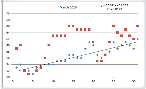
Surf at Bogue Pier ranged from high of 54-degrees to a low of 44-degrees with an average of 49.9-degrees (blue diamonds). Bogue Sound had a high of 60-degrees and a low of 35-degrees with an average of 49.6-degrees (red squares). Last Feb. average for the surf was 45.3, sound 42.0. Much more moderate this year.

Fullscreen capture 432016 113310 AM.bmp

Posted by & filed under Articles.


Braided line, why, how and trouble free usage! by Dr. Bogus

http://www.ncoif.com/braided-line-trouble-free-usage-by-dr-bogus/


  • What are super-braid fishing lines?
    1. Remember the original braided fishing line? Dacron polyester by DuPont.
    2. Today’s gel-spun polyethylene fibers make up the NEW braided fishing lines
      1. Fireline, PowerPro, Tuf Line, Sufix etc.
      2. Not for casual user, took me 2-years to get comfortable with use and knots.
  • Alternatives, low stretch mono lines-coated/copolymers/fluorocarbon
  1. Advantages (why?)
    1. Smaller diameter for equivalent strength of mono lines
      • 30/12, 20/6, 15/4, 10/2, 8/1 (250/80)
      • Use of smaller lighter reels with same line capacity (extra line capacity)
      • Less water resistance, less weight needed for getting line to bottom or trolling
      • Better casting distance
      • Little or no line memory, good for cold weather use
      • Extra strength and abrasion resistance Easier to pull fish away from pilings etc.
    2. Little or no line stretch (vs. rubber band stretch of mono lines)
      • 0 to 5% vs. 15 to 25% (20 feet/100 feet of line!)
      • Sensitivity, feel hat fish is doing, feel light hits (e.g. winter trout bump)
        • Original instant messaging (IM) system!
      • Quick hook sets (line moves the same distance as your rod tip)
        • Feel faster, hook faster, equals more hookups
  1. Disadvantages (why not?) WIND KNOTS are a MYTH…OPERATOR ERROR!
    1. Slippery: need backing on reels or will slip, knots may slip (two-sided tape)
      • Palomar, uni; Albright (20 turn), surgeon’s (four turns), uni to uni knot
    2. Soft, limp and thin: wind loops/knotting, wrapping of guides, hard to untangle knots and backlashes and snarls (hard to “pick” out tangle). Some are coated or fused.
      • Fuji guide design helps minimize looping/wind knots
  • Cutting, line is difficult, need special scissors, also I burn off end to a bead, to stop fraying
  1. Will cut through mono lines of neighboring anglers and your fingers too!
  2. May slip through eyes, split rings, snaps and other small gaps
  1. Tips
    1. Careful to not overmatch your rod with higher strength line that rated (breaks)
      • Lighten drag to compensate for non-stretch (set to mono you would have used)
      • Use gentler hook-set, gentle sweep or wrist snap, don’t try to set hook and land fish in one motion!!
      • If hung-up, pull from spool to pull free or break off, NOT your rod or hands
    2. Under fill spool (minimize snarls from loose line/coils, good for mono too)
  • Close bail manually to eliminate loose coils and place line in bail roller
    • Raise rod tip to tighten line and remove loops.
    • Look for loose coils and cast and rewind tightly periodically through finger tips
    • If loop gets caught under line, pull line through roller do not open the bail and pull off of the top!!! Don’t cast to get rid of the loop or it will make a mess.
    • If you still get a know (you didn’t do what I said), but rub some ChapStick on the knot and it will be easier to get out.
  1. Use mono or fluorocarbon leader, braided lines are very visible (red braid???)
  2. 20-pound test braid will tangle less than 10-pound test